The people at the archive were super helpful and super knowledgeable -- so much so that I'll have to go back soon. At first they wondered -- as so many people do -- why I would be interested in manuscripts about colonial surveying, but when they heard my pitch, they got it immediately and started pulling out all kinds of good stuff. They even set up one of their own counter-top computers so I could look at some obscure digitized materials that hadn't yet been made widely available. One archivist shared with me her research on a crooked eighteenth-century surveyor-official who tried to use his position to steal another man's land. I'll be heading up to Princeton today to check out their collection of James Alexander papers (and maybe track down an old prof or two). But I'll be heading back to the NJSA tomorrow to dig around more in the New Jersey proprietary records, which are a treasure trove of materials on land and surveying. Many thanks to the NJSA staff for introducing them to me.
26 March 2014
Jersey's Pride: Its Archivists
Spent yesterday afternoon in the New Jersey State Archives in Trenton -- my first full day on a week-long research & conference trip here in New Jersey. I'll be doing archival research for a few days and then Friday I'll be participating in the "Conquest to Identity" conference hosted by the McNeil Center for Early American Studies, the New Jersey Council for the Humanities, the New Jersey Historical Commission, and Kean University.
08 May 2013
The Spirit of Geometry
 |
| Paul Hazard, from the Library of Congress. |
There are many parts of the text that are worth quoting, but here I want to offer a long passage from Bernard Le Bovier de Fontenelle's Histoire de l'Académie royale des sciences (1699):
The geometrical method is not so rigidly confined to geometry itself that it cannot be applied to other branches of knowledge as well. A work on politics, on morals, a piece of criticism, even a manual on the art of public speaking would, other things being equal, be all the better for having been written by a geometrician. The order, the clarity, the precision and the accuracy which have distinguished the worthier kind of books for some time past now, may well have been due to the geometrical method which has been continuously gaining ground, and which somehow or another has an effect on people who are quite innocent of geometry. It sometimes happens that a great thinker gives the keynote to the whole of his century. He to whom the distinction of endowing us with a new method of reasoning may most justly be awarded was himself an accomplished geometrician.
Fontenelle in action.

 |
| Rene Descartes |
| From Abraham Bosse, Traité des pratiques géométrales et perspectives (1665) |
Here's the original passage from Fontenelle, taken from an eighteenth-century edition of his writings:
The phrase "esprit géométrique" is more evocative than the one offered in the translation. And scholars have been quick to seize on it as a way to identify the mathematical and quantifying spirit of the age. (See, for example, the edited volume The Quantifying Spirit of the Eighteenth Century (1990), available here.)
 It's safe to say that this spirit took hold of Americans during the colonial and early republican eras. In
The Colonizing Trick: National Culture and Imperial Citizenship in Early America (2003), David Kazanjian links Fontenelle, Jefferson, Humboldt, and Foucault in the matter of a few pages, noting that "[t]his quantifying spirit was especially captivating in the United States" and that "Jefferson in particular must be considered a prophetic avatar of this infatuation."
Needless to say, surveyors were some of the key agents of this spirit, this loa of geometry, that spread through colonial America and the early United States. The Cartesian grid overlaid across North America was their work.
(In case you're curious, Hazard's book was originally published as La Crise de la conscience européenne in Paris in 1935, and is being reissued now by the New York Review Books (NYRB Classics) as The Crisis of the European Mind: 1680-1715, for about $20. Their books are beautiful and solid, and the new edition even comes with a new introduction by Anthony Grafton.)
 |
27 November 2012
Chainbearers, old & new
First published in 1845, James Fenimore Cooper's Chainbearer; or, The Littlepage Manuscripts is a novel about surveyors, love triangles, and the transformation of early America.
Here's a cover from the 1873 edition, available at archive.org:

And here's a rather different cover from the print-on-demand publisher Bibliobazaar that I found at paperbackswap.com:

The plot is pretty convoluted. Warren S. Walker has provided a helpful guide.
Here's a cover from the 1873 edition, available at archive.org:
And here's a rather different cover from the print-on-demand publisher Bibliobazaar that I found at paperbackswap.com:
The plot is pretty convoluted. Warren S. Walker has provided a helpful guide.
31 August 2012
He carried his own compass
George Washington began surveying when he was fifteen years old. This may have been his first survey in the field, a plan of a turnip field belonging to his half-brother, Lawrence Washington:
He was surveying on the day he died. Consider the recollection of his adopted son, George Washington Parke Custis:

"As was usual with him, he carried his own compass, noted his observations, and marked out the ground." -- A fitting epitaph for the first surveyor-president.
(An excellent overview of Washington's life as a surveyor with many links to materials within the collections of the Library of Congress can be found here.)
 |
| From the George Washington Papers at the Library of Congress. |
He was surveying on the day he died. Consider the recollection of his adopted son, George Washington Parke Custis:
"As was usual with him, he carried his own compass, noted his observations, and marked out the ground." -- A fitting epitaph for the first surveyor-president.
(An excellent overview of Washington's life as a surveyor with many links to materials within the collections of the Library of Congress can be found here.)
30 August 2012
Washington's Surveying Notebook, 1799
In April 1799, eight months before his sudden death, George Washington joined some of his neighbors in a survey of one of his many properties. He had met them at the recent election -- an election that saw Democratic-Republicans win many state and congressional offices in Virginia and elsewhere -- and had asked them to join him in a circuit around "Four Mile Run." I'm sure it didn't take much to convince these men to join the former president on this walkabout. One wonders if they talked politics or kept to less controversial subjects.

April 29.
Having seen at the Election on the 24th Inst., most of the persons whose lands adjoin mine on four mile run, I fixed with them (acquainting Mr. Ludwell Lee who was also concerned, by letter, therewith) to meet at 9 'o clock this day on the Land, at the Beginning Corner of Adam[ ] Patent, and went thither myself accordingly; -- where I was soon joined by Mr.. Will.m Adam Capt.n. Jerrett, Mr. Summers, Mr. Whiting, Mr. Luke, Mr. [ ] & Mr. Ball -- Mr. Lee being [the?] only interested person a[bsent?].
Col.o. Little, and Mr. Geor[ge] Minor were also present. Mr. Abner Rawlins carried Compass and _____ Ball & Rawlins the Chain.
The notebook is part of the wonderful and eclectic collections of the Rosenbach Museum and Library in Philadelphia. (And they have a few more pages from the notebook online, too, if you're interested.) They have James Joyce's manuscript of Ulysses, Marianne Moore's papers, a first edition of Don Quixote, and lots more.
20 July 2012
Amos Eaton's Mental Struggles
Amos Eaton was a lawyer, surveyor, scientist, author, and teacher and one of the founders of the Rensselaer School, what is now known as the Rensselaer Polytechnic Institute in Troy, New York. He published books on surveying, mathematics, geology, chemistry, and botany. His first book, published in 1802, was a surveying manual with a great title: Art Without Science, or the Art of Surveying, Unshackled with the Terms and Science of Mathematics.
His next book wouldn't be published until 1817, but there would be a steady stream of books from then on. His productivity as an author seems to have been set in motion by a period of incarceration at Greenwich Jail in New York City. He was imprisoned for about five years (1811-1815 or 1816) for allegedly forging documents in a land dispute that involved the powerful New York landlord Edward Livingston. Eventually he was given an unconditional pardon by the governor and released. It was during his time in prison that he began his scientific studies (and encouraged the scientific studies of young John Torrey, the son of a prison official). After leaving prison he spent a year as a student at Yale and then began a career as an itinerant science instructor in New England and New York.
In 1824 he offered some advice to his son Amos B. Eaton, then a cadet at West Point, about critics ("pigmy foplings" and "ephemeral scribblers") and the hard life of the mind.
 |
| From the US Geological Survey, via si.edu |
In 1824 he offered some advice to his son Amos B. Eaton, then a cadet at West Point, about critics ("pigmy foplings" and "ephemeral scribblers") and the hard life of the mind.
18 July 2012
The Compleat Surveyor, revived
I'm currently in the reading room of the American Antiquarian Society in Worcester, Massachusetts, looking into their amazing collection of printed materials related to early American surveying. Most of their published materials date to after 1800, which is when I want to wrap up my story. But as part of that effort to tell the story of the colonial surveyor, I need to get a better sense of how surveying, and surveyors, changed in the early republican period, too.
One example of a mid-19th century text in their collections is James Pedder's Farmers' Land-Measurer, or Pocket Companion, which went through a number of editions. The first edition appears to have been published in Philadelphia in 1842. The AAS holds editions from 1853 and 1854, which were published in New York.
What I like most is its cover, which you can also see in this online edition available on Archive.org (from the 1855/1856 edition).
11 April 2012
A Messy Convergence
Lately I've been reading a book that made a big impact in Canadian historical circles but that was unknown to me until fairly recently. It's John C. Weaver's The Great Land Rush and the Making of the Modern World, 1650-1900 (McGill-Queen's University Press, 2003).

It received several awards in Canada: the North American Conference on British Studies Book Prize (2004); the Wallace K. Ferguson Prize from the Canadian Historical Association (2004); the Canadian Prize in the Humanities (finalist, 2004); and, most impressively, the Francois-Xavier Garneau Medal (2010). Although it has much to say about "colonial America" (often implicitly defined as the British colonies south of Canada) and the nineteenth-century United States as well as Canada, it seems not to have had nearly the impact among historians in the U.S. as it did in Canada.
The book offers a comparative view of the British colonial "Neo-Europes" in North America, Australasia, and South Africa, focusing in particular on the role of property rights and land distribution. He draws from a wide variety of examples across empires and (post)colonial societies while engaging theoretical questions along the way. The writing is often dense and academic in style, but it is clear at the same time. That's important for a book that's nearly 500 pages long.
Most useful for my own purposes are chapters three and six, which focus on the practices of land measurement and distribution and the role of surveyors in these practices. But the book as a whole has a greater ambition than merely to outline the ways that property has been distributed. As Weaver notes in the introduction, "Neo-European settlement resulted from a messy convergence of private impertinence and the coercive might of the state" (5). It is this mutual constitution of individual and state through legal rights to property that is most interesting. Each empowers (and can undermine) the other.
Weaver ultimately emphasizes, however, that active government intervention is necessary to restrain the excesses that follow from turning the public domain into private property in the name of that old British, Lockean ideal of "improvement." Perhaps that is why Canadians have been more eager to embrace the book than their Neo-British cousins to the south.
(For a roundtable about the book at the Canadian Historical Association Conference in 2011, have a listen here. It's nearly an hour and a half long; Weaver begins speaking at the 59 minute mark.)
23 January 2012
Perspective in Motion
For a marvelous example of the kind of scroll painting that Hockney described, take a look at this eighteenth-century rendering of "Along the River During the Qingming Festival," found in the National Palace Museum in Taipei, Taiwan.
At the museum's website you can find a description of the painting and its history along with an interactive view where you can zoom & scroll, while Wikipedia offers a full-size version of the same image. As the Wikipedia entry notes, the scroll is meant to be read (or "travelled") from the right side to the left. It appears to my eye, as well, that most of the people in the painting are moving in that direction, too.
Take some time to make the journey--even on a little screen it's a remarkable experience.

A New Way of Seeing
In the introduction to Making Space: Revisioning the World, 1475-1600, John Rennie Short writes that "a new way of seeing" was invented during the Renaissance. This new way of seeing brought about a new kind of space: "a modern space of the grid, the map, and the survey." This way of seeing is our own: "We see the world through eyes that came into focus during the sixteenth century."

Short's bold arguments reminded me of an article I read by Lawrence Weschler in Harper's several years ago that made a profound impression upon me. It was a sort of philosophical profile of the English painter David Hockney, who, along with physicist Charles Falco, had proposed that optics had had a profound influence on painting during the Renaissance and, controversially, that many of the revered "Old Masters" themselves appear to have used optics (particularly the camera obscura) to create the "realistic" effects in their paintings.
Weschler's article in Harper's (unlike his first piece on Hockney in The New Yorker in 2000; see also his commentary on the response to his article in The Believer) didn't seek to evaluate what's now known as the Hockney-Falco thesis (it has its own entry in Wikipedia), but instead considered the way of seeing that Hockney argued came with the use (or non-use) of optics in art.
In the article Hockney notes that "the essential point I was trying to make . . . is that from an artist's point of view--especially back then in the early fifteenth century--even just to see it (the projection, that is, of three-dimensional reality onto a two-dimensional surface) was to use it." This mechanical way of seeing--and its single-point perspective--had a powerful influence on artists. "[T]he main point is, pictures influence pictures--it's as simple as that. Pictures frame how we then go on to see, and thus seeing, to portray."
Hockney compares Chinese painting from the same era to the western "optical" style, noting how the Chinese style applies light and perspective in a completely different manner. Vantage points are multiple, not single, which creates a different kind of space within the painting, and a different kind of relationship with the viewer: "We as viewers are in that world, not outside of it." The multiple vantage points do not create confusion--the effect is quite the opposite: "it all coheres visually, it all makes sense. A different way of seeing: arguably more true to life."
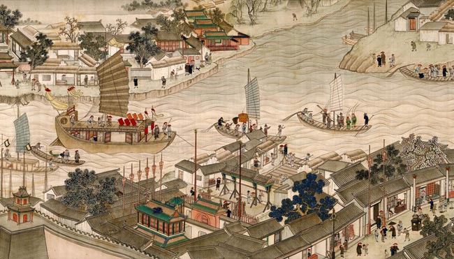 |
| 18th-Century Scroll Painting National Museum of Chinese History, Beijing (Image from Asianart.com) |
This was Hockney's complaint and it seems to be Short's, too.
 |
| David Hockney, Garrowby Hill, 1998 Museum of Fine Arts, Boston (Image from La Louver.) |
20 January 2012
Dutch landscapes, Dutch things
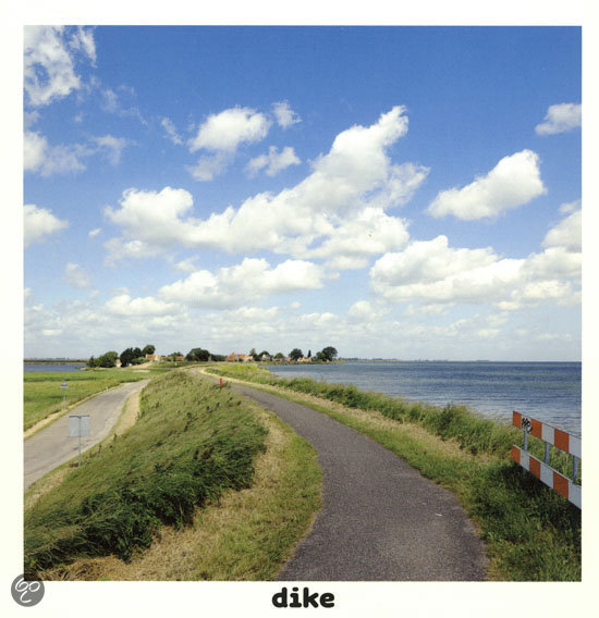
Recently I was reading a new children's book called Dutch Things, by Nathalie Farber and Matthijs Immink. The book is a translation of Hollandse Dingen (& vice versa), and shows clever pictures of typical (and not-so-typical) Dutch objects and scenes along with words that apply to them. The landscape of the Netherlands features in several photos--polder, dike, and the final page in the book, patchwork, which features an image of an immaculate grid of green fields that butt up against a dike lined with wind turbines and a sea beyond.
It is a commonplace to note that the Dutch landscape (and seascape) is a central part of Dutch identity--historians such as Simon Schama and Donna Merwick and many Netherlanders themselves often have seen their landscape and their methods of addressing the relationship between land and water as central to who they are. The choices of polder and dike in Dutch Things are clear examples of that identification with the man-made landscape.
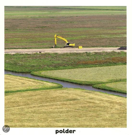
The image for patchwork, though, struck me more forcefully, as it shows the surveyor's influence so readily. Indeed, the Netherlands was at the forefront of land surveying in the early modern period, in part because so much of its landscape was the product of reclamation. New lands could be measured, bought, sold, regulated, and taxed efficiently with the new methods of the time.
Surveyors were key players in these processes of making the Dutch landscape. The word landscape in English originally comes from seventeenth-century Dutch landschap, which, Svetlana Alpers writes, referred "to both what the surveyor was to measure and what the artist was to render" ("The Mapping Impulse in Dutch Art," in Art and Cartography: Six Historical Essays, edited by David Woodward).
Dutch landscapes made by Dutch surveyors: Dutch things.
15 January 2012
Literary and Scientific, combined with Land-Surveying
That's what Henry David Thoreau listed as his "Occupation" in the questionnaire he returned to the American Association for the Advancement of Science in 1853. Thoreau's self-description applies just as well to the book in which I found this reference, Patrick Chura's Thoreau the Land Surveyor (University Press of Florida, 2010), which offers fascinating insights into Thoreau's efforts to live by his own ethical and ecological credos and to work as a surveyor in Concord. The work is not just interesting because of what it says about Thoreau, but also because of how it says it--blending the "Literary and Scientific," complete with illustrations of Thoreau's techniques and accounts of Chura's own attempts to reproduce them. It's a book that's given me much to think about and some ideas about how to proceed with my own project about colonial surveyors.
Here's a link to Chura's faculty page at the University of Akron, where he teaches in the English Department. And here's a link to Thoreau the Land Surveyor at the University of Florida Press.
(This survey of Walden by Thoreau comes from the Concord Free Public Library
Thoreau survey collection. They have a wonderful online exhibition here.)
Here's a link to Chura's faculty page at the University of Akron, where he teaches in the English Department. And here's a link to Thoreau the Land Surveyor at the University of Florida Press.
 |
| Walden Pond, manuscript survey (ink on paper), [1846]. |
Subscribe to:
Posts (Atom)